Blencathra - G/LD-008 SOTA (2021)

Summits on the Air Activation Report
Activation Date: Tuesday 1st June, 2021.
Activator(s): Richard M1HAX.
Summit: Blencathra, Lake District, England.
Summit ID: SOTA reference G/LD-008 (8 points).
Summit Height: 868m elevation, 461m prominence.
Summit Location: Lat./Long. 54.63995, -3.04979. Maidenhead Grid IO84lp.
Distance: 9.1km travelled with 710m of ascent.
Difficulty: SAC Grade T4 / Grade 1 Scramble.(?)
Elapsed Time: 4hr 20m (including operating).
Weather: 25°C, 12 mph ENE wind, 52% humidity.
Radio Equipment: Yaesu FTM100D, MFJ-1714, Zippy 4200mAh 4S LiFePo4. Yaesu VX6, Diamond SRH770S.
Callsign Used: M1HAX/P.
Contacts: 12 (2m FM, 70cm FM).
Trip Notes
Blencathra, also known as Saddleback, is a prominent northern fell in the English Lake District, standing at 868 metres. The mountain features six distinct tops with Hallsfell Top being the highest. Originally named Saddleback by the Ordnance Survey, it’s now commonly known by its ancient Cumbric name Blencathra, which was popularized by Alfred Wainwright. From the summit, expansive views stretch across to Skiddaw in the west and the Back o’Skiddaw fells to the northeast.
For this early summer ascent, I parked on the roadside near the village of Scales. This area provides limited free parking, and being a perfect June day, I was fortunate to find a spot early in the morning.
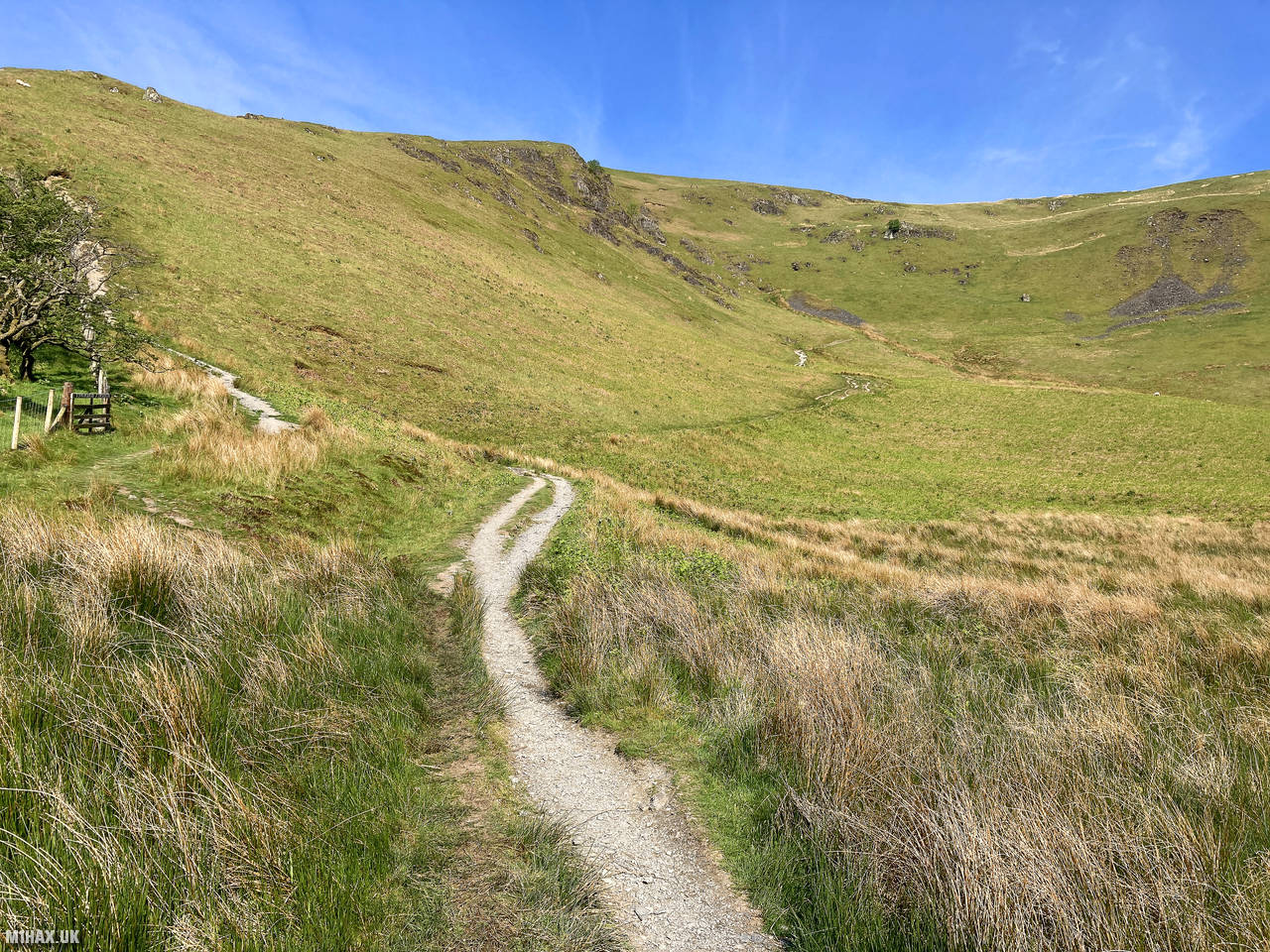
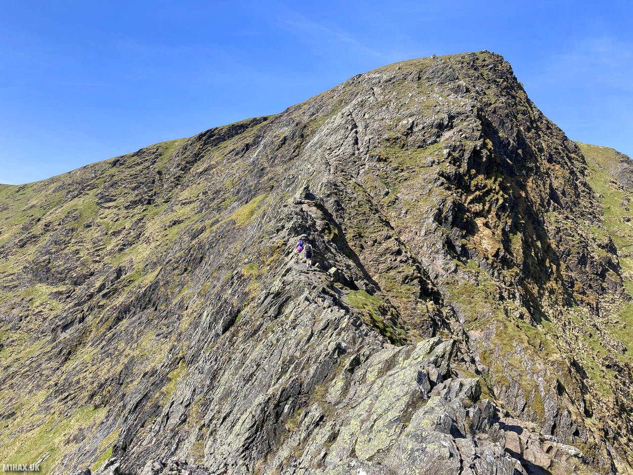
From the parking area, I headed northeast on a well-defined path before turning northwest to skirt around the lower slopes of Blencathra. The route followed a good footpath parallel to the River Glenderamackin, where the infamous Sharp Edge scrambling ridge soon came into view in the distance.
Several other walking parties were visible on this popular route, all taking advantage of the perfect weather conditions. Sharp Edge is a Grade 1 scramble that, while not technically difficult in dry conditions, becomes notoriously treacherous when wet. The dry rock today made for an enjoyable, if relatively brief, scrambling experience. Fatalities have occurred here, particularly in poor weather, so proper assessment of conditions is essential before attempting the route.
The views from the scramble were spectacular in the clear sunshine, with panoramic vistas across the northern Lake District. After completing the ridge section, I joined the main footpath heading south toward the summit of Blencathra.
At the summit, I set up my portable amateur radio station and completed a pleasant activation on the 2-metre band. I managed 12 contacts, including a summit-to-summit (S2S) with Duncan MM0GOG/P who was operating from GM/SS-029 (Broad Law) in Scotland. I also made one contact on 70cm with Aigars M7AVT.
For the descent, I chose the southward route down Halls Fell Ridge. This offers another scrambling option, but is quite manageable in descent on a dry day. The circuit back to the car completed my activation of this excellent 8-point Lake District summit in a little over four hours.
Blencathra is a magnificent mountain that offers multiple approach routes of varying difficulty. The Sharp Edge scramble should be reserved for competent scramblers and good weather conditions.
Photos
Below are some photographs taken during my activation of Blencathra on Tuesday 1st June, 2021.


Walking Route for Blencathra
The interactive map below shows my GPS track taken to the SOTA activation zone for Blencathra. The G/LD-008 summit area is marked on the map with a blue pin icon.
You can download the route shown above as a GPX file suitable for use with most GPS devices. This file is provided for information only, to support your own walk planning and research (it may contain navigation errors, detours and/or safety hazards). The route downloads provided here are governed by the Creative Commons BY-NC-SA 4.0 licence.
Station Log
I logged the following 12 amateur radio contacts operating as M1HAX/P from G/LD-008 Blencathra on Tuesday 1st June, 2021 (all times shown are UTC):
| Time | Callsign | Band | Mode | Notes |
|---|---|---|---|---|
| 09:54 | G1OAE | 2m | FM | Tony, 5/9 |
| 09:56 | 2E0LDF/P | 2m | FM | Reg, 5/9 |
| 09:57 | M7AVT | 2m | FM | Aigars, 5/9 |
| 09:58 | 2E0XUP/P | 2m | FM | Steve, 5/9 |
| 09:59 | G1OHH | 2m | FM | Sue, 5/9 |
| 10:00 | G4WHA/M | 2m | FM | Geoff, 5/9 |
| 10:01 | M0YMC | 2m | FM | Mal, 5/9 |
| 10:02 | G4ZRP | 2m | FM | Brian, 5/9 |
| 10:02 | G7CDA | 2m | FM | Douggie, 5/7 |
| 10:04 | G0MHF | 2m | FM | John, 5/7 |
| 10:07 | MM0GOG/P | 2m | FM | Duncan, 5/9, S2S GM/SS-029 |
| 10:13 | M7AVT | 70cm | FM | Aigars, 5/8 |
In the notes field I will usually log the other operator’s name and the signal report they provided. In accordance with the Summits on the Air rules, I do not make a log entry where a complete exchange of callsigns and signal reports was unsuccessful.
Additional Information
The following resources may be helpful to walkers, mountaineers and SOTA activators interested in Blencathra:
- Sotl.as Summit Page for G/LD-008 Blencathra.
- Hill Bagging UK Summit Page for Blencathra.
- Google Maps Page for Blencathra.
- Wikipedia entry for Blencathra.
- 360° Panorama near summit of G/LD-008 Blencathra.
If you found this content valuable, why not Buy Me a Coffee?