Y Lliwedd - GW/NW-008 SOTA (2021)

Summits on the Air Activation Report
Activation Date: Thursday 1st July, 2021.
Activator(s): Richard M1HAX.
Summit: Y Lliwedd, North Wales, Wales.
Summit ID: SOTA reference GW/NW-008 (8 points).
Summit Height: 898m elevation, 154m prominence.
Summit Location: Lat./Long. 53.05948, -4.05705. Maidenhead Grid IO73xb.
Also Activated: GW/NW-001.
Distance: 19.6km travelled with 1425m of ascent.
Difficulty: SAC Grade T3 / Grade 1 Scramble.(?)
Elapsed Time: 7hr 55m (incl. operating and other summit(s) on the same hike).
Weather: 22°C, 5 mph NE wind, 79% humidity.
Radio Equipment: Yaesu VX6, Diamond SRH770S.
Callsign Used: MW1HAX/P.
Contacts: 11 (2m FM).
Trip Notes
Y Lliwedd is a distinctive peak in Snowdonia, Wales, standing at 898 metres above sea level. It forms part of the famous Snowdon Horseshoe, a challenging ridge walk around the Snowdon massif. The mountain features dramatic cliffs and rocky faces, making it popular for scrambling and climbing. Its steep north-eastern face overlooks Llyn Llydaw, and it holds historical significance as one of the early training grounds for Everest expeditions.
For this hike, I started from the large pay and display car park in Llanberis, following the popular Llanberis Path towards Snowdon. This route is the easiest way to the summit of Snowdon and follows a well-maintained gravel footpath alongside the mountain railway line.
About two-thirds of the way up, the path crosses underneath the railway at the Clogwyn Station. This bridge provided some much-appreciated shade on what was becoming a hot, sunny, blue skies day. Visible on the horizon was Clogwyn d`Arddu, a steep cliff on Snowdon’s northern face known for its challenging rock-climbing routes and history of rare alpine plants. The Eastern Terrace here offers a grade 2 scrambling route that I’d like to tackle at some point in the future.
After approximately 7 kilometres, I reached the final push up to Snowdon’s summit, where I was treated to a spectacular cloud inversion in every direction. The views were entirely breathtaking, with a sea of clouds below and clear blue skies above.
Rather than lingering at the crowded summit, I continued directly onwards, descending along part of the Watkin Path towards Bwlch y Saethau at approximately 800 metres altitude. The views from here across Afon Glaslyn and towards Crib Goch were excellent.
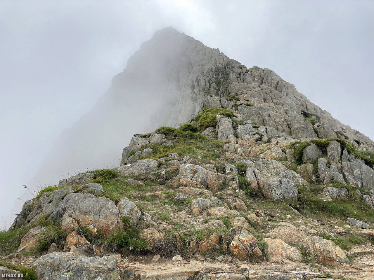
From this point, I began my ascent towards Y Lliwedd along Grade 1 scrambling terrain, trying to keep close to the cliff face on my left to make the most of the route. The scrambling was enjoyable and a significantly different experience compared to when I had previously ascended here in subzero winter conditions in 2019. After about 600 metres of moderate scrambling, I reached the west peak of Y Lliwedd, unfortunately now in cloud with limited views.
At the summit, I quickly set up my Yaesu VX6 handheld radio with its Diamond SRH770S antenna and made 11 contacts on the 2-metre band. The highlight was a summit-to-summit contact with Andrew GM4VFL/P on White Coomb (GM/SS-030) in Scotland - a remarkable distance of roughly 265 kilometres for a 5-watt handheld radio! I also had the pleasure of making contact with Richard GW3CWI/P, one of the founders of the Summits on the Air scheme.
With little visibility to enjoy the views and my SOTA activation complete, I packed away my equipment and prepared to descend. My plan was to promptly return to Snowdon’s summit where I intended to make as many radio contacts as my battery would permit before completing the journey back to Llanberis.
This linear route combining Snowdon and Y Lliwedd made for a substantial day’s hiking - covering nearly 20 kilometres with almost 1,500 metres of ascent - but the combination of spectacular cloud inversions, pleasant scrambling, and successful radio contacts made it thoroughly worthwhile.
Photos
Below are some photographs taken during my activation of Y Lliwedd on Thursday 1st July, 2021.


Walking Route for Y Lliwedd
The interactive map below shows my GPS track taken to the SOTA activation zone for Y Lliwedd. Note that this summit was activated as part of a multi-summit hike and the map below shows the full route taken on the day. The GW/NW-008 summit area is marked on the map with a blue pin icon.
You can download the route shown above as a GPX file suitable for use with most GPS devices. This file is provided for information only, to support your own walk planning and research (it may contain navigation errors, detours and/or safety hazards). The route downloads provided here are governed by the Creative Commons BY-NC-SA 4.0 licence.
Station Log
I logged the following 11 amateur radio contacts operating as MW1HAX/P from GW/NW-008 Y Lliwedd on Thursday 1st July, 2021 (all times shown are UTC):
| Time | Callsign | Band | Mode | Notes |
|---|---|---|---|---|
| 10:08 | GM4VFL/P | 2m | FM | Andrew, 5/6, S2S GM/SS-030 |
| 10:09 | MW7GWR | 2m | FM | Dave, 5/9 |
| 10:10 | G6MHF | 2m | FM | John, 5/9 |
| 10:10 | G1PIE | 2m | FM | Mark, 5/9 |
| 10:11 | M0VAZ | 2m | FM | John, 5/9 |
| 10:12 | G0HRT | 2m | FM | Rob, 5/7 |
| 10:13 | G0VEO | 2m | FM | Russ, 5/7 |
| 10:13 | GW3CWI/P | 2m | FM | Richard, 5/7 |
| 10:14 | 2E0AGB | 2m | FM | Allen, 5/5 |
| 10:15 | GW8GLW | 2m | FM | Irfon, 5/9 |
| 10:16 | MW0WMW | 2m | FM | Mike, 5/9 |
In the notes field I will usually log the other operator’s name and the signal report they provided. In accordance with the Summits on the Air rules, I do not make a log entry where a complete exchange of callsigns and signal reports was unsuccessful.
Additional Information
The following resources may be helpful to walkers, mountaineers and SOTA activators interested in Y Lliwedd:
- Sotl.as Summit Page for GW/NW-008 Y Lliwedd.
- Hill Bagging UK Summit Page for Y Lliwedd.
- Google Maps Page for Y Lliwedd.
- Wikipedia entry for Y Lliwedd.
- 360° Panorama near summit of GW/NW-008 Y Lliwedd.
If you found this content valuable, why not Buy Me a Coffee?