St Boniface Down - G/SE-008 SOTA (2025)
Summits on the Air Activation Report
Activation Date: Saturday 27th September, 2025.
Activator(s): Richard M1HAX.
Summit: St Boniface Down, Southern England, England.
Summit ID: SOTA reference G/SE-008 (1 point).
Summit Height: 242m elevation, 242m prominence.
Summit Location: Lat./Long. 50.60357, -1.19759. Maidenhead Grid IO90jo.
Distance: 0.1km travelled with 0m of ascent.
Difficulty: Drive on summit.
Elapsed Time: 55m (including operating).
Weather: 15°C, clear, 9kph S wind, 77% humidity.
Radio Equipment: Elecraft KX2, EFHW, Yaesu FTM100D, Slim-J, Zippy 4200mAh 4S LiFePo4.
Callsign Used: M1HAX/P.
Contacts: 31 (20m SSB, 40m SSB, 2m FM).
Trip Notes
St Boniface Down stands at 242 metres as the highest point on the Isle of Wight, making it a Marilyn with prominence equal to its elevation. The name connects to St Boniface (c.672-754 AD), born Wynfrith in Wessex, who became known as the Apostle of the Germans. Local legend holds that he visited nearby Bonchurch around 710 AD, preaching to fishermen from Pulpit Rock. The Old Church of St Boniface at Bonchurch dates to approximately 1070 and may stand where he originally preached.
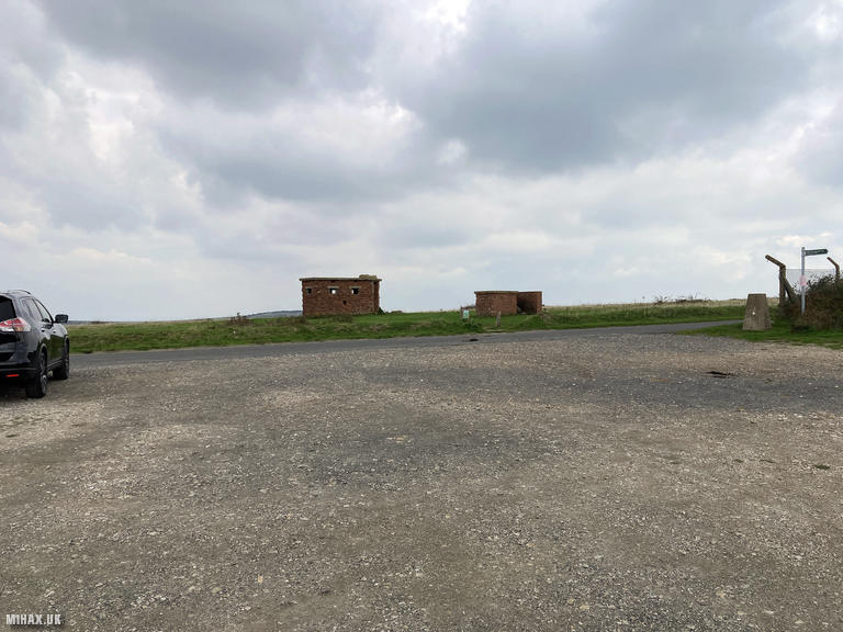
The summit carries significant wartime history. RAF Ventnor operated here as one of twenty original Chain Home radar stations, with four 350-foot steel transmitter masts becoming operational by January 1939. On 12th August 1940, twenty Junkers Ju88 bombers devastated the station - a scene later recreated in the 1969 film Battle of Britain. German intelligence mistakenly believed the station remained operational underground, a critical error that aided Britain’s air defence.
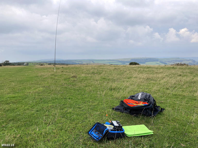
I drove up the steep but well-surfaced access road past Littleton Down towards the summit. The National Trust offers free unmanaged parking with space for several vehicles. Dog walkers and other visitors were enjoying the fine September morning. From the car park, I walked a short distance past some disused buildings to find a large grassy area where I set up at the edge of a faint path. A trig point stands nearby.
For this activation I deployed my Elecraft KX2 with an end-fed half-wave wire antenna on a SOTABeams carbon fibre pole. These poles are exceptionally compact and lightweight - ideal for hiking and travel - but rather fragile. Since acquiring my KX2 in 2023, I have broken and replaced five of them.
Despite a cold wind, operating conditions proved excellent. I worked a substantial pile-up on 20 metres SSB, completing nineteen contacts across Europe including four summit-to-summit contacts: OE5YYN/P on Osojnica in Austria, DG4SFF/P and DC1GB/P sharing an activation on a German summit, and SQ9BQW/P in Poland. After exhausting 20m, I switched to 40 metres for UK contacts including Robert M0RWX, an experienced SOTA activator whom I more usually work on 2m FM. Three contacts on 2 metres FM rounded out the operation. The EFHW antenna yielded significantly more contacts than the compromised AX1 I had used the previous afternoon at Butser Hill - unsurprising given the more sensible size of the antenna.
This is a very accessible summit which I recommend for those seeking a quick activation or wishing to deploy heavier radios or large antenna systems.
Photos
Below are some photographs taken during my activation of St Boniface Down on Saturday 27th September, 2025.

Station Log
I logged the following 31 amateur radio contacts operating as M1HAX/P from G/SE-008 St Boniface Down on Saturday 27th September, 2025 (all times shown are UTC):
| Time | Callsign | Band | Mode | Notes |
|---|---|---|---|---|
| 09:17 | F4HTV | 20m | SSB | RSTr: 55, RSTs: 58 |
| 09:17 | EA1DHB | 20m | SSB | RSTr: 55, RSTs: 57 |
| 09:18 | S57ILF | 20m | SSB | RSTr: 55, RSTs: 55 |
| 09:20 | OE5PZM | 20m | SSB | RSTr: 44, RSTs: 54 |
| 09:21 | EA3EVL | 20m | SSB | RSTr: 55, RSTs: 52 |
| 09:26 | OE5YYN/P | 20m | SSB | RSTr: 53, RSTs: 56, S2S OE/OO-063 |
| 09:26 | OH3GZ | 20m | SSB | RSTr: 57, RSTs: 57 |
| 09:27 | DG4SFF/P | 20m | SSB | RSTr: 56, RSTs: 58, S2S DM/BW-845 |
| 09:28 | DC1GB/P | 20m | SSB | RSTr: 56, RSTs: 58, S2S DM/BW-845 |
| 09:29 | SQ9BQW/P | 20m | SSB | RSTr: 55, RSTs: 56, S2S SP/BZ-057 |
| 09:30 | IK0XBU/P | 20m | SSB | RSTr: 53, RSTs: 51 |
| 09:31 | DH3TK | 20m | SSB | RSTr: 56, RSTs: 58 |
| 09:32 | KL7TC | 20m | SSB | RSTr: 41, RSTs: 56 |
| 09:33 | LA6YJA | 20m | SSB | RSTr: 57, RSTs: 57 |
| 09:34 | EA4ACS | 20m | SSB | RSTr: 56, RSTs: 55 |
| 09:35 | DC7WC | 20m | SSB | RSTr: 55, RSTs: 57 |
| 09:36 | IU2SOK | 20m | SSB | RSTr: 56, RSTs: 52 |
| 09:37 | MM7TKU | 20m | SSB | RSTr: 59, RSTs: 58 |
| 09:38 | OH9FKJ | 20m | SSB | RSTr: 53, RSTs: 42 |
| 09:41 | M0RWX | 40m | SSB | RSTr: 57, RSTs: 57 |
| 09:41 | G0FEX | 40m | SSB | RSTr: 57, RSTs: 57 |
| 09:42 | G7SXR | 40m | SSB | RSTr: 55, RSTs: 58 |
| 09:43 | PD3RL | 40m | SSB | RSTr: 42, RSTs: 53 |
| 09:43 | GW4RFT | 40m | SSB | RSTr: 55, RSTs: 54 |
| 09:44 | MM0MDA | 40m | SSB | RSTr: 55, RSTs: 51 |
| 09:46 | 2E0BIA/P | 40m | SSB | RSTr: 55, RSTs: 55, S2S G/SP-004 |
| 09:47 | M6BLV | 40m | SSB | RSTr: 59, RSTs: 58 |
| 09:47 | M0ZXQ | 40m | SSB | RSTr: 57, RSTs: 58 |
| 09:53 | 2E0OWI/M | 2m | FM | RSTr: 59, RSTs: 59 |
| 09:55 | G0RIB | 2m | FM | RSTr: 59, RSTs: 59 |
| 09:57 | M0LBO/P | 2m | FM | RSTr: 59, RSTs: 53 |
In the notes field I will usually log the other operator’s name and the signal report they provided. In accordance with the Summits on the Air rules, I do not make a log entry where a complete exchange of callsigns and signal reports was unsuccessful.
Additional Information
The following resources may be helpful to walkers, mountaineers and SOTA activators interested in St Boniface Down:
- Sotl.as Summit Page for G/SE-008 St Boniface Down.
- Hill Bagging UK Summit Page for St Boniface Down.
- Google Maps Page for St Boniface Down.
- Wikipedia entry for St Boniface Down.
If you found this content valuable, why not Buy Me a Coffee?