Bioda Buidhe - GM/SI-081 SOTA (2025)
Summits on the Air Activation Report
Activation Date: Wednesday 22nd October, 2025.
Activator(s): Richard M1HAX.
Summit: Bioda Buidhe, Scottish Islands, Scotland.
Summit ID: SOTA reference GM/SI-081 (1 point).
Summit Height: 466m elevation, 183m prominence.
Summit Location: Lat./Long. 57.61471, -6.28977. Maidenhead Grid IO67uo.
Distance: 3.9km travelled with 235m of ascent.
Difficulty: SAC Grade T2.(?)
Elapsed Time: 1h 25m (including operating).
Weather: 10°C, sunny, 24kph W wind, 72% humidity.
Radio Equipment: Elecraft KX2, Elecraft AX1.
Callsign Used: MM1HAX/P.
Contacts: 12 (20m SSB).
Trip Notes
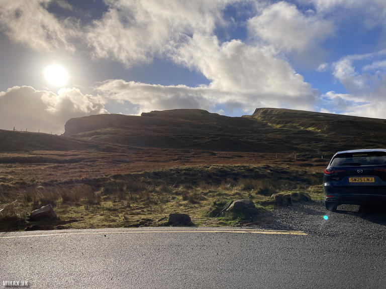
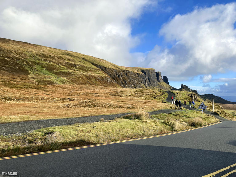
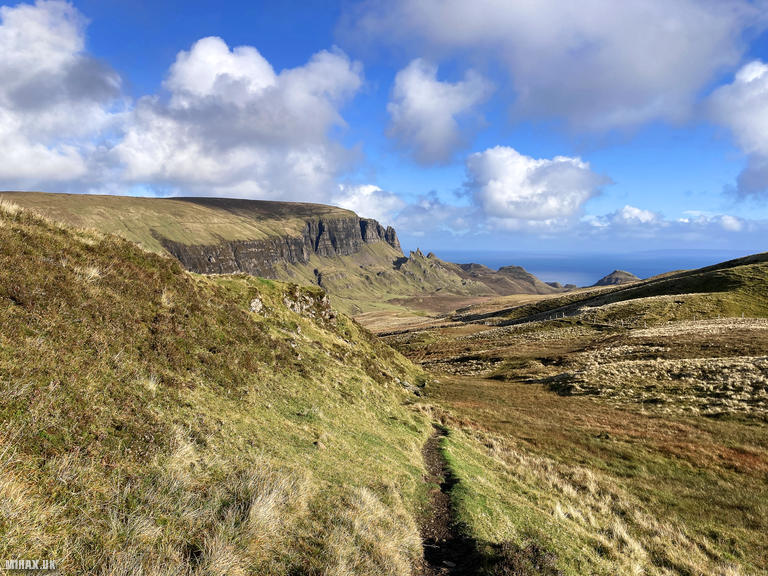
Bioda Buidhe rises to 466 metres on the Trotternish Ridge, the spectacular spine that dominates northern Skye. The Gaelic name translates as “yellow point” - buidhe meaning yellow, derived from Old Irish buide. This summit forms part of Britain’s largest continuous landslide terrain, where 300 metres of Paleocene basalt lavas have slipped over weaker Jurassic sedimentary rocks since the last ice age retreated approximately 17,000 years ago. The Quiraing landslip to the north, covering 8.5 square kilometres, remains one of Europe’s most impressive geological features.
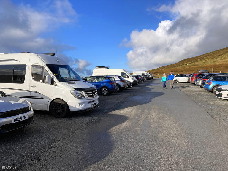
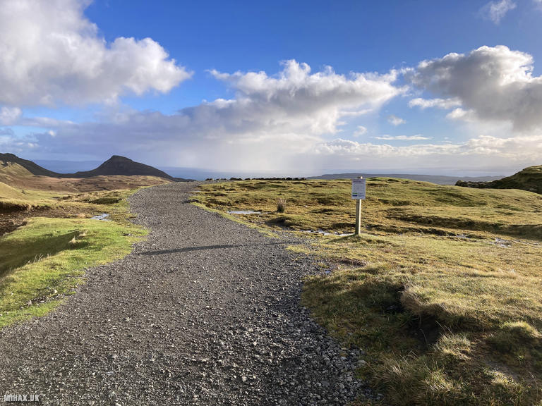
I activated this hill during a family holiday to Skye. After a short drive from our accommodation near Flodigarry, we arrived at the busy pay and display car park on the Quiraing road between Staffin and Uig. The neighbouring summit of Meall na Suiramach to the north was clearly drawing most visitors following a break in recent inclement weather and virtually everyone was heading towards the famous Quiraing viewpoint.
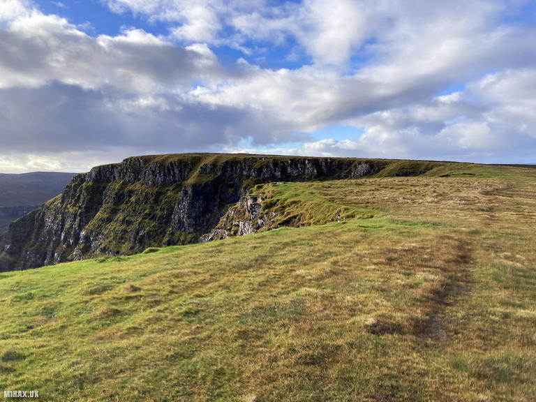
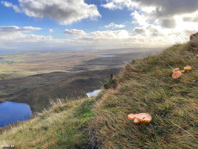
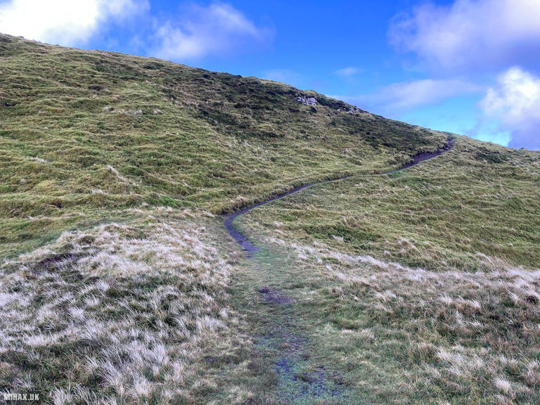
The route south towards Bioda Buidhe proved far quieter. Initially the path follows an obvious track to a viewpoint before dipping down to cross a small stream. An established grass trail then heads south, handrailing along the steep eastern cliffs. The views from this escarpment are excellent, looking down to the coastal settlements and across to the Scottish mainland. Interestingly, I spotted several waxcaps growing on the exposed cliff edge here - most likely Meadow Waxcaps (Cuphophyllus pratensis), identifiable by their peachy-orange, dry fibrous caps. These grassland fungi are excellent indicators of ancient, unimproved pasture and thrive on Skye’s nutrient-poor soils.
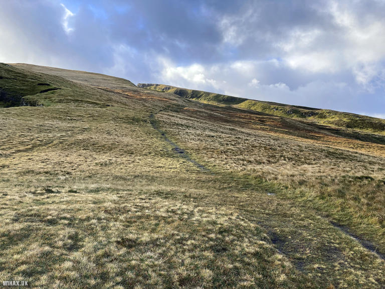
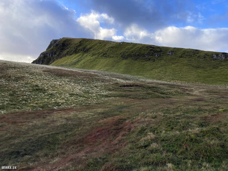
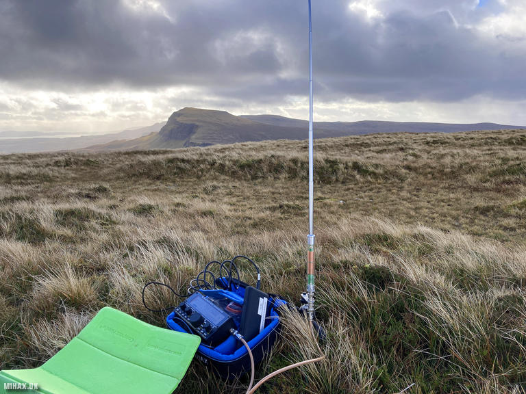
At approximately 330 metres elevation the route forks south-west to gain the final ridge towards the summit plateau. The terrain levels out considerably here, following a faint trail across the featureless top. Despite the summit’s modest appearance compared to the dramatic landslip features nearby, it offers exceptional panoramic views south along the Trotternish Ridge towards The Storr, and north-west to the Outer Hebrides.
Setting up on the ground at the summit, I deployed my Elecraft KX2 with the compact AX1 antenna. Conditions on 20 metres proved favourable and I worked twelve stations across Europe in quick succession, including regular chasers EA1DHB and OH3GZ. The cold wind made for uncomfortable operating, so after logging my contacts we promptly prepared to descend via the same route.
I particularly enjoyed this walk - the contrast with the crowds at the Quiraing could not have been starker. Despite the very busy car park, we encountered no other walkers on Bioda Buidhe. For activators seeking a quieter alternative to Skye’s more famous summits, this Marilyn offers an excellent combination of geological interest, fine views, and relative solitude.
Photos
Below are some photographs taken during my activation of Bioda Buidhe on Wednesday 22nd October, 2025.

Walking Route for Bioda Buidhe
The interactive map below shows my GPS track taken to the SOTA activation zone for Bioda Buidhe. The GM/SI-081 summit area is marked on the map with a blue pin icon.
You can download the route shown above as a GPX file suitable for use with most GPS devices. This file is provided for information only, to support your own walk planning and research (it may contain navigation errors, detours and/or safety hazards). The route downloads provided here are governed by the Creative Commons BY-NC-SA 4.0 licence.
Station Log
I logged the following 12 amateur radio contacts operating as MM1HAX/P from GM/SI-081 Bioda Buidhe on Wednesday 22nd October, 2025 (all times shown are UTC):
| Time | Callsign | Band | Mode | Notes |
|---|---|---|---|---|
| 10:09 | EA1DHB | 20m | SSB | RSTr: 54, RSTs: 57 |
| 10:10 | SM5DXT | 20m | SSB | RSTr: 57, RSTs: 56 |
| 10:10 | G0RQL | 20m | SSB | RSTr: 55, RSTs: 53 |
| 10:11 | M0OMC | 20m | SSB | RSTr: 55, RSTs: 53 |
| 10:11 | DL3JPN | 20m | SSB | RSTr: 55, RSTs: 56 |
| 10:12 | SA4BLM | 20m | SSB | RSTr: 57, RSTs: 53 |
| 10:13 | F4WBN | 20m | SSB | RSTr: 57, RSTs: 55 |
| 10:13 | CT1EBA | 20m | SSB | RSTr: 52, RSTs: 57 |
| 10:15 | HB9EVF | 20m | SSB | RSTr: 53, RSTs: 53 |
| 10:15 | G4FKA | 20m | SSB | RSTr: 55, RSTs: 58 |
| 10:15 | DL8DXL | 20m | SSB | RSTr: 55, RSTs: 55 |
| 10:16 | M8JJS | 20m | SSB | RSTr: 52, RSTs: 51 |
In the notes field I will usually log the other operator’s name and the signal report they provided. In accordance with the Summits on the Air rules, I do not make a log entry where a complete exchange of callsigns and signal reports was unsuccessful.
Additional Information
The following resources may be helpful to walkers, mountaineers and SOTA activators interested in Bioda Buidhe:
- Sotl.as Summit Page for GM/SI-081 Bioda Buidhe.
- Hill Bagging UK Summit Page for Bioda Buidhe.
- Google Maps Page for Bioda Buidhe.
- Wikipedia entry for Bioda Buidhe.
If you found this content valuable, why not Buy Me a Coffee?